
Compatibility
Minecraft: Java Edition
Platforms
Supported environments


Tags
Creators
Details
Overview
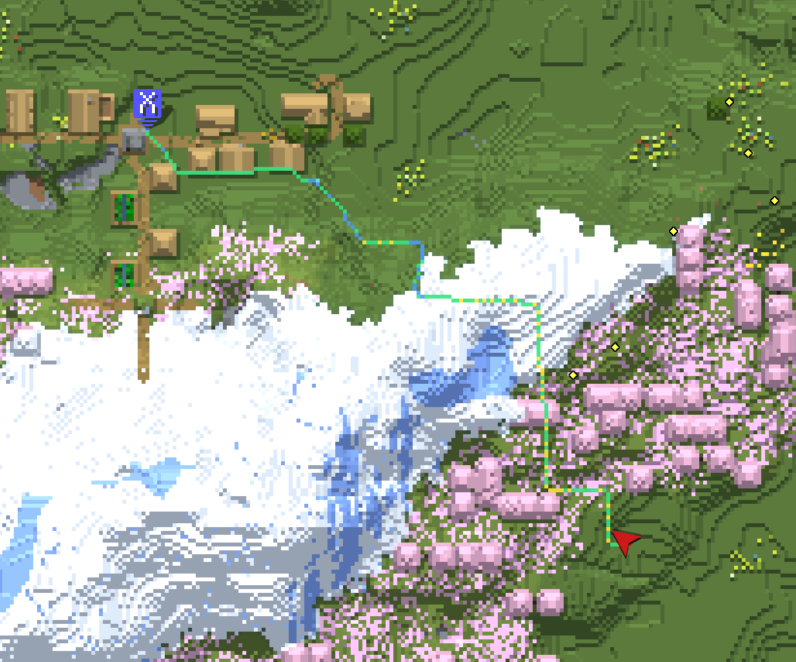
This mod adds pathfinding to Xaero's Minimap and Xaero's World Map
This mod does not support auto-walking ⚠️
How it works
-
Routes over real terrain, not straight-line distance.
The A* search combines walking, climbing, swimming, descending, ladders/vines, riding a boat, riding a minecart, jumping 1–3 block gaps, digging, and bridging over gaps with placed blocks. -
Blocks used for bridging are budgeted against what you actually carry.
A route that needs more blocks than you have is only offered when there is no other way through, and the HUD tells you how many are missing. A route that would burn through most of your stack loses to a slightly longer one that places fewer blocks. Turn onstrictLimitsif you would rather get no route than one that breaks these limits. -
Minecart routes, even beyond your render distance.
XaeroNav remembers the rails you have seen in each world and dimension. When you carry a minecart, or one is already sitting on the rails, routes can ride them, including rails outside the loaded area. The HUD tells you where to get on and when to get off. -
Routes on mounts.
While riding a horse, donkey, mule, skeleton horse, zombie horse or camel, the route stays on ground your mount can walk and jump, keeps out of water, and tells you where to jump. If the way on needs you to get off, the HUD says where. A harnessed happy ghast gets the same aerial guidance as an elytra, and a nautilus follows the water. -
Long-distance routes are calculated in stages.
First, a rough route is drawn using Xaero's Map data so it can reach beyond the chunks currently loaded around the player.
The loaded area around you is also turned into a navigation graph in the background, and the detailed search uses it to aim straight at the destination. Past the edge of that graph, it falls back to the rough route.
It also supports paths with multiple vertical layers, for example in the Nether, where different passages can overlap at the same XZ coordinates but at different heights. In dimensions with a ceiling, the rough route is a 3D cost table built from Xaero's Map data. -
Recalculates only when needed.
Small deviations from the line while walking don't trigger a redraw, so the guidance stays stable instead of flickering. -
Time left to the destination.
The HUD shows the time left to the destination, even when only part of the route has been found. The rest is estimated and gets more accurate as you walk. -
Warns you before danger, not after.
Segments next to lava, digging that could flood the area, falls without a safe landing, and swims that would run out of breath are all colored differently from normal movement. When there is room, walking routes keep a block away from lava, the void and deadly drops. -
Works even without Xaero.
Map drawing and the right-click menu are disabled, but pathfinding, in-world rendering, and the on-screen guidance still work. -
Elytra guidance.
Under a roof or in the Nether, the mod plots a 3D flight path that avoids terrain and follows it with its own deviation check and recalculation interval. Under open sky, it puts a light beam where you should land, and the HUD shows an arrow toward it and the distance. Touch down and it goes back to walking guidance toward the same destination.
How to use
| Method | Action |
|---|---|
| World map | Right-click empty space on the map → "Navigate Here" |
| Waypoint | Right-click a waypoint → "Navigate Here" |
| Keybind | "Navigate to the block you are looking at" (unbound by default) |
| Command | /xaeronav goto <x> <y> <z> |
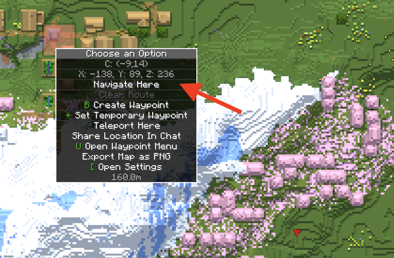
No matter which method you use, your destination is displayed on Xaero's map, so you'll know where you're headed without following the line to its end. With Xaero's Minimap installed, it's registered as a temporary waypoint: it stays upright as the minimap rotates, moves to the edge with a distance readout once it's off screen, and shows in the world like any other waypoint. It's never saved to disk, and it disappears when you clear the route.
Point at a natural tree or a huge mushroom on the map and the destination becomes the ground at its foot, so you aren't sent up into the leaves.
Stops
Once a destination is set, right-click the map or a waypoint to add places to visit on the way (up to 10).
| Option | What it does |
|---|---|
| Add as Stop (Insert) | Keeps the destination and slots the stop in where it adds the least detour |
| Make This the Final Destination | The current destination becomes a stop, and this place becomes the new end |
| Remove This Stop | Shown when you right-click a stop's marker |
Stops appear on the map as numbered light-blue markers, and the HUD shows which stop you are heading to. The route on the map and in the world carries on through every stop to the destination. Stops are not saved and are gone when you leave the world.
Route colors
| Color | Meaning |
|---|---|
| Green | Walking (also riding a horse or camel) |
| Yellow | Climbing up |
| Blue | Climbing/stepping down |
| Dark blue | Swimming |
| Light cyan | Riding a boat (a boat-shaped outline marks where to place it) |
| Light gray | Riding a minecart |
| Purple | Ladder / vine |
| Pink | Jumping a gap |
| Orange | Digging (target block outlined) |
| Cyan | Bridging with placed blocks |
| Red | ⚠ Adjacent to lava |
| Magenta | ⚠ Void below |
| Light blue | ⚠ Digging lets water flow in |
| Reddish pink | ⚠ Swim segment with no breath left |
| Orange-red | ⚠ Fall that deals damage |
| Teal | Fall softened by placing water at the last moment (MLG) |
| Pale orange | ⚠ Sneaking across a magma block |
| Off-white | Dotted line for a stretch with no known route (heads toward the unexplored destination) |
| Amber | Coarse waypoint chain for a long-distance route |
| Sky blue | Aerial path while gliding under a roof or in the Nether |
| Pale yellow beam | Where to land while gliding under open sky |
| Red pin | The destination, drawn by XaeroNav when Xaero's Minimap is not installed (stays the same size on screen at any zoom) |
Warning colors take priority over movement-type colors — danger needs to read first.
Commands
| Command | What it does |
|---|---|
/xaeronav goto <x> <y> <z> |
Set the destination |
/xaeronav via add <x> <y> <z> |
Add a stop (order picked automatically) |
/xaeronav via append <x> <y> <z> |
Add a stop at the end |
/xaeronav via list |
List the stops and the destination |
/xaeronav via remove <number> |
Remove a stop |
/xaeronav clear |
Clear the route |
/xaeronav version |
Print the running build (include this in bug reports) |
/xaeronav debug |
Print the current state for a bug report (versions, dimension, position, destination, route, Xaero hooks, key settings); also copied to the clipboard |
/xaeronav debug probe |
Measure toward the current destination: Xaero map data around you, the long-distance route, and what the detailed search reached and why it stopped |
The debug commands don't change your route. If a route detours, stops short or never appears, run both where it happens and attach the output to a bug report. The output includes your coordinates and the world seed, so check it before posting it publicly.
Known Limitations ⚠️
-
Requires at least 2 GB of Java heap (the official launcher's default).
-
Searches are limited to loaded chunks and are terminated by the maximum number of expansion nodes. For distant destinations, the path ends partway, and the remainder is shown as a dotted line (the rest will be calculated as you proceed). The HUD also displays a message that the route continues past the searched area.
-
The search range is limited by Minecraft's render distance (128 blocks at a render distance of 8). Chunks not sent from the server cannot be read, and since the vanilla protocol does not include packets to request chunks, the mod cannot retrieve them on its own. If long-distance navigation cuts off midway, increase the render distance.
-
The navigation graph covers up to 224 blocks around you, or 160 blocks with less than 2.5 GB of Java heap, and never more than your render distance. It is rebuilt every 8 blocks you walk, which uses about half of your CPU cores for up to 2 seconds.
-
Long-distance routes using Xaero map data cannot be used if Xaero is not installed or if you have never visited that region (the system will fall back to on-the-spot calculations based on loaded chunks). Map data downloaded by Xaero's Maps: Multiplayer+ is used like your own, except in cave mode, where no surface map is written.
-
The HUD is not displayed while walking with no destination set. While gliding with an elytra it shows the direct distance and upcoming climbs (or the landing beam's direction and distance under open sky) instead of turn-by-turn directions.
-
Routes that cross dimensions are not supported. If you move to a different dimension, the destination will be cleared.
-
Map integration is implemented by plugging into Xaero's internal system. If this structure changes in a new version of Xaero, only that specific part will become disabled, and a one-time chat notification will be sent upon joining the world to indicate what has been disabled. In-world rendering and the HUD will continue to function as usual.
-
Surface-first routing does not work in dimensions without a sky (the Nether and The End).
MIT (LICENSE).
How routing works → A detailed walkthrough of how routes are found and kept up to date.
Movement cost baselines are informed by measurements used in Baritone (LGPL), but the code itself is an independent implementation.